
About Karimnagar
A Legacy of Courage, A Future of Opportunity
Origin & History of Karimnagar
From Ancient Origins to a Glorious Legacy – Discover the Story of Karimnagar
The historical trajectory of Karimnagar is a captivating journey through time, rooted deeply in the ancient soil of Telangana. Originally known as Elgandal, the region served as a vital political and economic epicenter for some of South India’s greatest empires. It witnessed the dawn of the powerful Satavahana dynasty, with the nearby site of Kotilingala acting as their inaugural capital and a bustling hub of early maritime trade. As centuries progressed, the formidable Kakatiya kings fortified the landscape, leaving behind an indelible architectural footprint of magnificent stone fortresses and ingenious irrigation networks that sustained the region for generations.
The transition into modern Karimnagar took shape during the 18th century under the Asaf Jahi Nizam era, when the city was renamed in honor of the revered fort commander, Syed Karimuddin. By 1905, the administrative heart officially shifted from the hilltop fortress of Elgandal to the burgeoning plains below, setting the stage for contemporary growth. Beyond its strategic military importance, the district carved out a global reputation for artistic brilliance through its exquisite silver filigree craft—an intricate, lace-like metalwork technique that earned a prestigious Geographical Indication (GI) tag. Today, Karimnagar beautifully balances this glorious legacy, standing proud as a dynamic economic and educational powerhouse while fiercely preserving the cultural soul of its ancestors.
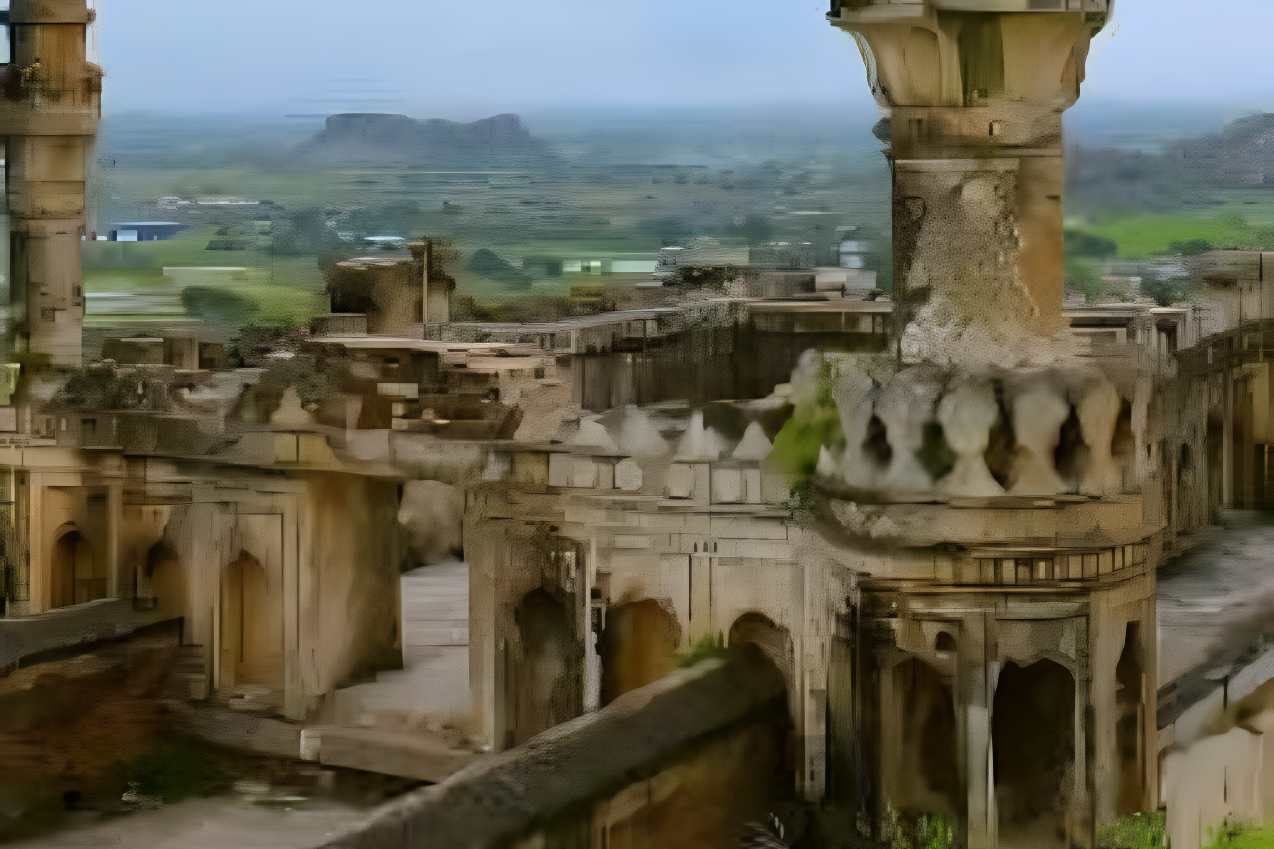
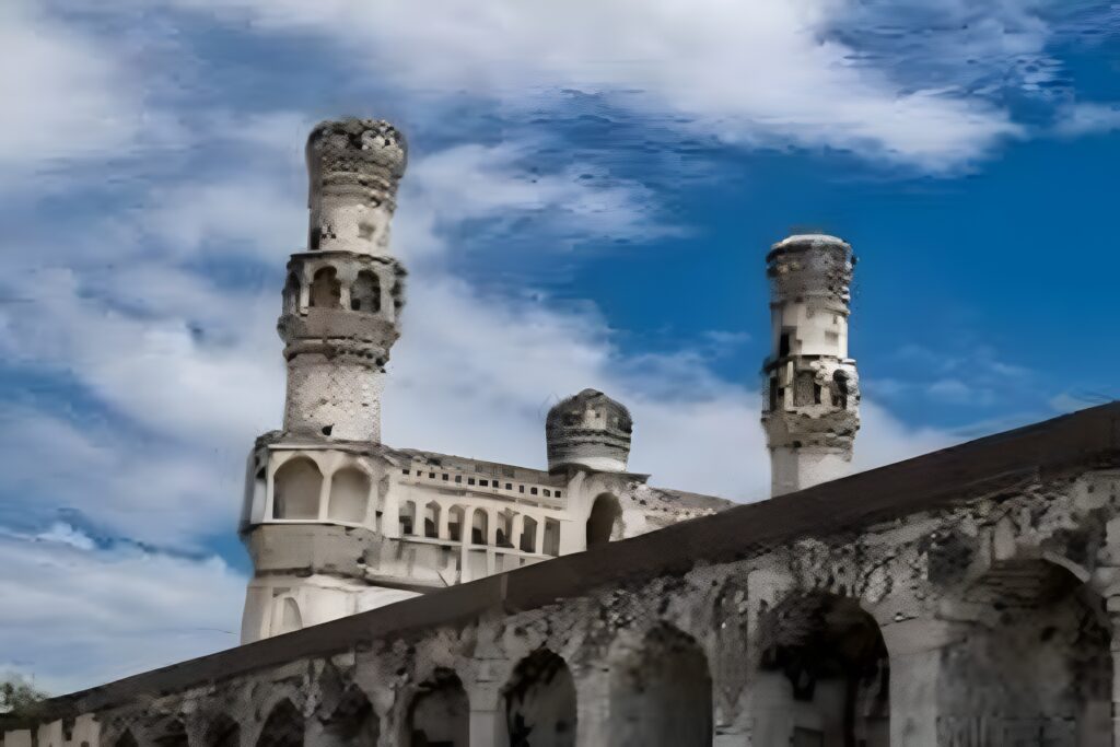
The image highlights the historic Elgandal Fort, also locally known as Elagandala Khilla, which is located a few kilometers from Karimnagar city. Originally established during the ancient Kakatiya dynasty, this formidable hillfort stands on a prominent hill along the banks of the Manair River. Its commanding stone walls, watchtowers, and steep steps reflect its past as an impenetrable military stronghold designed to guard the region. The fort’s defensive architecture uniquely featured a wide, deep moat that was historically filled with crocodiles to deter enemy invaders. For centuries, Elgandal Fort served as the central administrative headquarters of the Karimnagar region. It remained the pivotal seat of power until 1905, when the district headquarters was officially shifted to the rapidly growing Karimnagar town below. Today, the ruins house notable landmarks like the iconic Dho Minar (the two tall minarets) and the Brindavan tank. The site offers visitors a panoramic view of the vast Karimnagar countryside, preserving the deep heritage of the local soil.
Administrative Divisions
Efficiently Organized, Seamlessly Governed
Karimnagar Revenue Division
The administrative heart of Karimnagar District, Karimnagar Revenue Division oversees several mandals and plays a vital role in governance, public services, infrastructure development, and regional administration. As the district headquarters, it serves as a key center for commerce, education, and civic activities.
Mandals: Karimnagar, Karimnagar Rural, Kothapally, Manakondur, Thimmapur, Ganneruvaram, Gangadhara, Ramadugu, Choppadandi, and Chigurumamidi.
Huzurabad Revenue Division
The administrative heart of eastern Karimnagar District, Huzurabad Revenue Division oversees several mandals and plays a vital role in governance, public services, infrastructure development, and regional administration. As a prominent divisional headquarters, it serves as a key center for commerce, education, and civic activities within the region.
Mandals: Huzurabad, Veenavanka, V. Saidapur, Jammikunta, Ellandakunta, and Shankarapatnam.
About Karimngar District
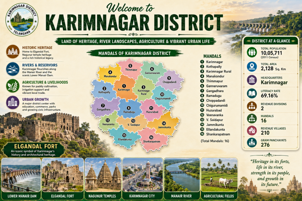
A Land of History, Heritage, and Cultural Excellence
Karimnagar District is one of the most historically significant districts in Telangana, known for its rich cultural heritage, ancient monuments, educational institutions, and agricultural prosperity. The district was officially reorganized on 11 October 2016 as part of Telangana’s administrative restructuring. Karimnagar city serves as the district headquarters and is an important center for education, commerce, and regional development.Located on the banks of the Manair River, Karimnagar is renowned for its historical landmarks, including the majestic Elgandal Fort, ancient temples, and archaeological sites that reflect the region’s glorious past. The district is also famous for its traditional silver filigree craftsmanship, granite industry, fertile agricultural lands, and vibrant cultural festivals. With a blend of urban growth and rural charm, Karimnagar has emerged as one of Telangana’s prominent cultural and economic hubs.
Important Towns in Karimnagar
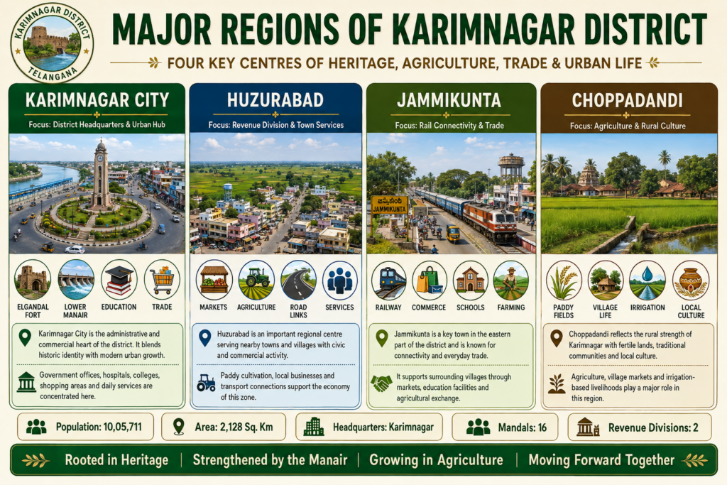
Karimnagar City – Population: Approximately 2,97,000
Karimnagar is the district headquarters and largest city, serving as a major center for education, healthcare, business, and administration. It is also known for Elgandal Fort and Lower Manair Dam.
Jammikunta – Population: Approximately 35,000
Jammikunta is an important commercial town with a strong agricultural economy, mainly producing paddy, maize, and cotton. It is well connected by road and rail.
Huzurabad – Population: Approximately 46,000
Huzurabad is a growing town known for agriculture, local markets, and improving education, healthcare, and infrastructure.
Choppadandi – Population: Approximately 25,000
Choppadandi is a developing town with an agriculture-based economy. It also serves as a local hub for education, trade, banking, and public services.
Economy of Karimnagar
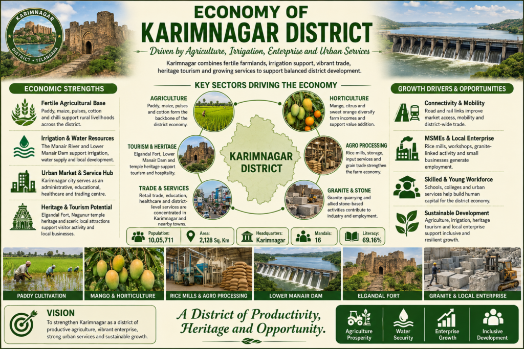
Karimnagar District has a diverse and rapidly growing economy driven by agriculture, industry, trade, education, and services. Agriculture remains the backbone of the district, with paddy, maize, cotton, turmeric, and various horticultural crops cultivated extensively across its fertile lands. The district is also known for its granite industry and the world-famous silver filigree craftsmanship, which contribute significantly to local employment and exports. Irrigation projects such as the Lower Manair Dam support agricultural productivity and rural livelihoods. In addition, Karimnagar’s expanding educational institutions, healthcare facilities, retail businesses, and transportation networks have strengthened the service sector, making the district one of Telangana’s important economic and commercial centers.The presence of irrigation projects such as the Lower Manair Dam has significantly enhanced agricultural productivity. Karimnagar is also renowned for its granite industry and traditional silver filigree craftsmanship, both of which contribute to employment and economic growth. In addition, the district’s expanding education, healthcare, retail, and transportation sectors have strengthened its position as an important commercial and economic center in Telangana.
Geographical Profile
Where fertile lands and natural beauty define Karimnagar
 Geographical Quick FactsTotal
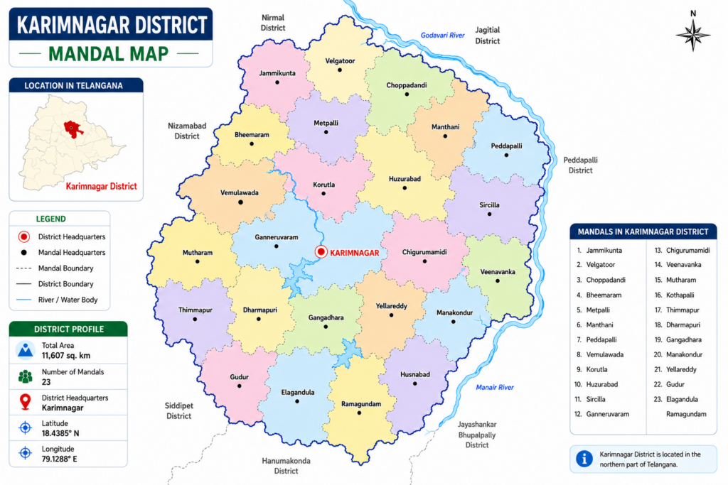
 Total Area: 2,128 sq. km District Headquarters: Karimnagar
 Location: North-central region of Telangana
 Climate: Dry Inland (Hot Summers & Cold Winters)
 Primary Land Use: Agriculture|
 Major River: Manair River (Tributary of the Godavari River)
 Terrain: Deccan Plateau upland with red sandy soils, graded valleys, and isolated granite hills
 Natural Features: Agricultural Fields, Granite Boulder Formations, and Reservoir Water Spreads
 Surrounding Regions
 North: Jagtial District and Peddapalli District
 East: Jayashankar Bhupalpally District and Rajanna Sircilla District
  South: Hanamkonda (Warangal Urban) District and Jangaon District
 West: Siddipet District and Rajanna Sircilla District
Population & Demographics
A vibrant and diverse population that drives the district’s growth and cultural richness
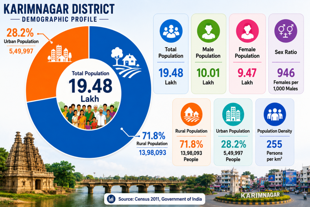
Karimnagar District is one of Telangana’s prominent cultural and economic regions, known for its rich heritage, agricultural strength, and growing urban development. The demographic profile highlights a total population of approximately 19.48 lakh people, with a significant majority residing in rural areas. Agriculture continues to be the backbone of the district’s economy, supporting thousands of families across its villages, while urban centers contribute to trade, education, healthcare, and industrial growth.
The district reflects a balanced social structure, with a male population of 10.01 lakh and a female population of 9.47 lakh, resulting in a sex ratio of 946 females per 1,000 males. With nearly 28.2% of the population living in urban areas and 71.8% in rural regions, Karimnagar maintains a strong connection to its agricultural roots while steadily advancing toward modernization. Its blend of traditional values, historical significance, and developing infrastructure makes Karimnagar an important district in northern Telangana.
Weather,Climate and Seasonal Features
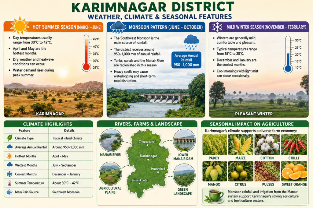
Weather Report of Karimnagar District experiences a tropical inland climate characterized by hot summers, a seasonal monsoon, and mild winters. Summers, which extend from March to June, are generally hot and dry, with daytime temperatures ranging between 30°C and 42°C. April and May are usually the hottest months, and occasional heatwave conditions may occur during this period. The southwest monsoon, arriving between June and October, is the primary source of rainfall and provides an average annual precipitation of around 950–1,000 mm. This rainfall replenishes the Manair River, reservoirs, and irrigation systems that support the district’s agriculture. Winters, from November to February, are pleasant and comfortable, with temperatures typically ranging from 15°C to 28°C and cooler mornings during December and January. The favorable climate, combined with reliable monsoon rainfall and irrigation from the Lower Manair Dam, supports the cultivation of major crops such as paddy, maize, cotton, chilli, pulses, mangoes, and citrus fruits, making agriculture a vital part of Karimnagar’s economy.